Via Augusta: The History of a Street.
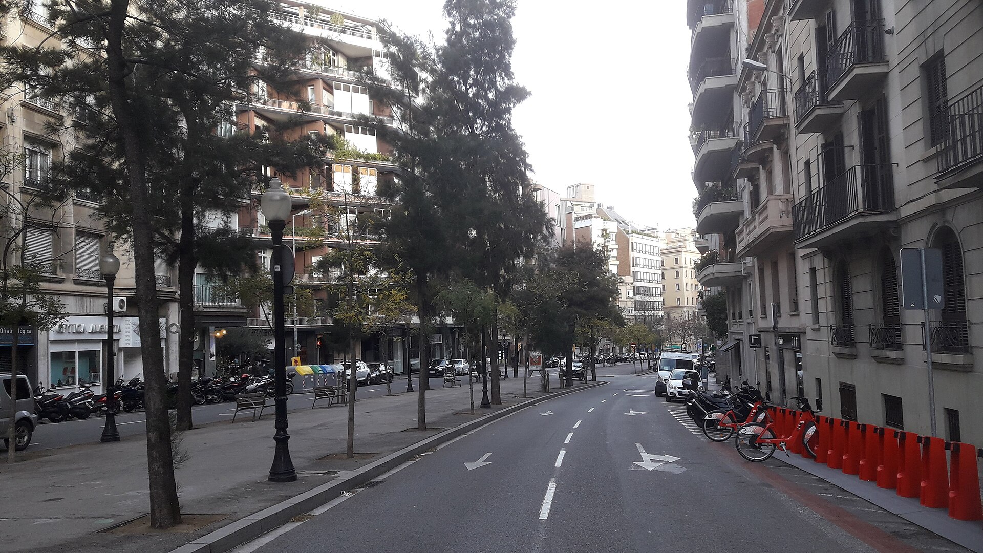
From the Great Roman Road to the Heart of the Contemporary City
There are streets in Barcelona that simply cross the city.
And there are others that, when we walk along them, seem to contain several cities at once.
Via Augusta belongs to the second category.
Today we know it as an important artery running through the western part of Barcelona, connecting the area around Avinguda Diagonal with Sarrià and the routes leading towards Collserola. But hidden behind its modern name lies a much longer history: ancient roads, the expansion of the municipalities of the old Pla de Barcelona, the birth of the Sarrià railway, the covering-over of the railway tracks, and the transformation of former rural and residential areas into the city we know today.
Its name comes from one of the great roads of the Roman world.
But the Via Augusta we see today should not simply be understood as a preserved Roman road.
Its history is much more complex.
It is the story of how Barcelona has gradually been built upon its own roads.
The Roman Via Augusta
A road that crossed Hispania
Long before modern Barcelona existed, Rome had created an extraordinary communications network linking cities, territories, ports, and agricultural areas throughout the Empire.
Among these great routes was the Via Augusta, one of the principal roads of Hispania.
Its route connected the Mediterranean territories of the peninsula with Rome and reached Gades, present-day Cádiz, following much of the western Mediterranean coast.
Around Barcelona, the Roman road network connected Barcino with other cities and settlements along the coast.
Archaeological evidence confirms that a coastal branch of the Via Augusta connected Blandae — Blanes —, Iluro — Mataró —, Baetulo — Badalona — and Barcino.
The road was not merely infrastructure for travellers.
Goods, people, soldiers, agricultural products, and news travelled along it.
In reality, it was one of the great structures that made the Roman world function.
The Arrival of Rome in Barcelona
Barcino becomes part of a network of roads
The foundation of Barcino took place approximately between 15 and 10 BC, during the reign of Emperor Augustus.
The new colony was given the name Colonia Iulia Augusta Faventia Paterna Barcino and was incorporated into the Roman territorial network.
Barcelona’s position was particularly advantageous.
The city was beside the Mediterranean, on a fertile plain, and close to important land routes.
Rome did not build its cities in isolation.
It connected them.
And Barcino became part of that network.
Different roads led out from the city towards other parts of the territory, while the main routes connected it with the rest of Hispania.
The Via Augusta and Roman Barcelona
A connection that can still be traced beneath the city
One of the great misconceptions when discussing the Via Augusta is to imagine that the present-day avenue preserves exactly the same route as the Roman road throughout its entire length.
The reality is much more interesting.
The historic Via Augusta had different routes, branches, and modifications, and the development of Barcelona meant that roads were transformed over the centuries.
Archaeological research has made it possible to locate remains of the Roman road at different points within today’s urban fabric.
One of the most interesting examples was discovered around the present-day Mercat de Sant Antoni, where remains of the Via Augusta were documented together with structures from the founding period of Barcino and funerary monuments.
At that time, the road passed through areas that lay outside the city walls.
And here another fascinating element of Roman Barcelona appears.
The Dead Also Lived Beside the Roads
The Via Augusta as a funerary landscape
For the Romans, roads were not merely places of transit.
They were also places of memory.
Roman law prohibited burials within cities, so necropolises were generally located beside the roads leading towards the urban gates.
This explains the existence of several funerary areas around Barcino.
At today’s Plaça Vila de Madrid, for example, an important Roman funerary road has been preserved, with burials located alongside an ancient road. The area was used between the 1st and 3rd centuries AD.
Visitors entering or leaving the city would therefore encounter tombs and funerary monuments on both sides of the road.
It was a way of keeping the dead present.
The road connected the living with the memory of those who had died.
When the Roman City Disappeared
The transformation of the roads
With the disappearance of the Roman Empire, the road network did not vanish overnight.
The roads continued to be used.
Some lost importance.
Others were modified.
Some sections were absorbed into new medieval streets and roads.
Barcelona slowly grew around its historic centre and, for centuries, the territory beyond the city walls consisted of fields, vegetable gardens, vineyards, farmhouses, and small settlements.
The ancient network of roads continued to shape that geography.
The city was still far from becoming the enormous Barcelona we know today.
The Road to Sarrià
Before the great buildings came fields and farmhouses
For centuries, the territory west of Barcelona was essentially rural.
Sarrià was an independent settlement, surrounded by fields and country houses.
Its historic centre developed around the church of Sant Vicenç and a network of roads connecting the settlement with Barcelona and neighbouring territories.
Today’s Sarrià still preserves traces of that past.
Barcelona did not incorporate Sarrià until 1921, making it the last of the former municipalities of the Pla de Barcelona to become part of the city.
But before Sarrià became part of Barcelona, something happened that would forever change the history of what would eventually become Via Augusta.
The railway arrived.
The Birth of the Sarrià Railway
The railway revolution of the 19th century
In 1863, the Barcelona–Sarrià Railway was inaugurated.
The line originally operated with steam locomotives and connected Barcelona with the then-independent municipality of Sarrià.
The arrival of the railway profoundly transformed this part of the city.
Where there had previously been roads, fields, and rural properties, a new infrastructure appeared, capable of rapidly transporting people between Barcelona and the surrounding municipalities.
The railway became one of the great engines of urbanisation.
And its route would eventually determine the shape of the future Via Augusta.
The Old Carril
The street that was not yet called Via Augusta
Before receiving its present name, part of the route was known as Carrer del Carril.
The name was not accidental.
The Sarrià railway ran through this area, and its presence profoundly affected everyday life.
The tracks crossed the territory at ground level and, in certain sections, ran through a cutting.
Residents needed bridges and crossings to get across them.
The urban landscape was divided by the railway.
And for decades, the train became an inseparable part of life in these neighbourhoods.
Historical documentation from the Farró district shows how the old Carrer del Carril was directly associated with the railway route and how various bridges were built to allow communication between neighbourhoods.
The Railway That Changed the City
An infrastructure that eventually created a new avenue
The Sarrià Railway enjoyed considerable success.
In 1905 it was electrified and converted to standard gauge.
But Barcelona’s growth was making the existence of surface railway tracks increasingly problematic.
The city was expanding.
The former municipalities were gradually being incorporated.
The Eixample was advancing.
Housing was multiplying.
And the railway line that in 1863 had represented progress was beginning to become, in an increasingly dense city, a physical barrier.
The solution would be radical:
the railway would be placed underground.
1929: Barcelona Puts the Railway Underground
The birth of a new city above the tracks
The transformation became particularly significant with the covering-over of the Sarrià Railway.
In 1929, the underground section between Plaça Catalunya and Muntaner was inaugurated, running beneath Balmes and the area corresponding to the future Via Augusta.
The change was enormous.
Where there had previously been tracks, level crossings, fences, and bridges, there was now the possibility of creating a new avenue.
The operation was not simply a transport project.
It also changed land values.
Former areas of villas and gardens gradually began to be transformed into higher-density residential districts.
The city was expanding towards Sarrià and Sant Gervasi.
1931: The Name Via Augusta Appears
An ancient Roman memory for a new avenue
The name Augusta began to be used officially in 1931.
The current designation Via Augusta was subsequently approved on 20 August 1940.
The choice was not accidental.
Barcelona was reclaiming, in its street names, the memory of the great Roman road that had formed part of the territory’s history.
The new name thus created a symbolic bridge between two completely different eras.
On one side stood the Rome of Augustus.
On the other was the modern Barcelona that had just radically transformed its railway and urban structure.
The new avenue had an ancient name.
But it was becoming a completely modern street.
An Avenue Built on Infrastructure
From railway to urban landscape
Over the following decades, the urbanisation of Via Augusta completely transformed the landscape.
The old railway tracks disappeared from the surface.
The level crossings ceased to exist.
Railway bridges were replaced.
And new pavements, buildings, and urban spaces began to appear.
The operation was not merely about mobility.
It also transformed land values.
Former areas of villas and gardens gradually gave way to higher-density residential districts.
The city expanded towards Sarrià and Sant Gervasi.
From Bourgeois Villas to Large Buildings
The transformation of Sant Gervasi
During the late 19th and early 20th centuries, many areas of Sant Gervasi and Sarrià were residential districts favoured by Barcelona’s bourgeoisie.
There were villas with gardens, large estates, farmhouses, and summer residences.
The arrival of the railway had greatly improved communications.
And putting the railway underground opened up new possibilities for urban development.
During the second half of the 20th century, many of these former properties disappeared, making way for apartment buildings.
The transformation was particularly intense from the 1960s onwards.
The former landscape of gardens and large plots gradually became the residential landscape that characterises much of Sant Gervasi today.
Via Augusta and Sarrià
The entrance to one of Barcelona’s historic neighbourhoods
As it moves westwards, Via Augusta approaches the historic centre of Sarrià.
Here the scale of the story changes.
We are no longer dealing solely with a modern urban avenue.
We are entering the territory of an ancient settlement that maintained its own identity for centuries.
Historic Sarrià can still be recognised through its small squares, narrow streets, traditional houses, and buildings connected with its past.
Via Augusta forms part of the landscape surrounding this historic centre and lies close to some of the former natural boundaries that shaped the territory.
It is one of those places in Barcelona where a major contemporary avenue merges with the memory of an ancient settlement.
The Porta de Sarrià
A symbolic gateway to the former municipality
At the junction of Via Augusta and Passeig de la Bonanova stands a particularly significant contemporary sculpture.
It is the Porta de Sarrià, created by Emili Armengol and inaugurated in 1993.
The sculpture functions symbolically as a gateway into the historic centre of Sarrià and establishes a relationship between this historic neighbourhood and Sant Gervasi.
It is an appropriate image for understanding Via Augusta.
A street that for centuries was a road.
A road that became a railway.
A railway that eventually became an avenue.
And an avenue that still functions as a gateway between different Barcelonas.
The Second Great Transformation
When Via Augusta grew again
The history of Via Augusta did not end when the railway was placed underground.
Throughout the 20th century it continued to transform.
The railway infrastructure itself continued to expand and change, while the city developed new transport systems.
In 1953, the underground extension of the railway between Muntaner and Sarrià was inaugurated.
The old relationship between railway and street continued to evolve.
The surface was increasingly freed from railway infrastructure, and Via Augusta gradually acquired its contemporary urban configuration.
Towards Collserola
Via Augusta becomes more than just an avenue
The most recent transformation took Via Augusta even farther.
During the second half of the 20th century, plans were developed to extend it towards the access routes to Collserola and Vallvidrera.
The development of the ring roads and new road infrastructure turned this area into a key connection between Barcelona and Vallès.
Today’s Via Augusta reaches towards the entrances to the Vallvidrera Tunnels, becoming part of a communications network completely different from the one that existed when the Sarrià Railway ran at ground level.
The ancient Roman road had been a territorial infrastructure.
Centuries later, the modern Via Augusta once again fulfilled a similar function:
connecting Barcelona with the territory around it.
A Street Between Gràcia and Sarrià-Sant Gervasi
Two urban worlds along a single route
Today, Via Augusta runs mainly through the districts of Gràcia and Sarrià-Sant Gervasi.
Its route connects very different environments.
From the area around Avinguda Diagonal to Sarrià and the approaches to Collserola, the character of the street constantly changes.
There are commercial areas.
There are residential buildings.
There are former bourgeois districts.
There are educational facilities.
There are railway stations.
And there are still corners where we can sense the landscape of Barcelona’s former outskirts.
This variety is precisely one of its greatest riches.
Via Augusta Underground
The city we cannot see
Perhaps one of the most fascinating aspects of Via Augusta is that much of its modern history is literally beneath our feet.
While we walk along the surface, the trains of the Ferrocarrils de la Generalitat de Catalunya run beneath the avenue.
Today’s railway infrastructure is the descendant of the old Sarrià Railway that began operating in 1863.
Street and railway still share the same urban space.
They simply do so on different levels.
History has not disappeared.
It has simply been hidden underground.
The Via Augusta of Buildings
Architecture that tells the story of the 20th century
Walking along Via Augusta also allows us to observe Barcelona’s architectural evolution.
Along its route are residential buildings, former facilities, buildings associated with the bourgeoisie of Sant Gervasi, and later architecture that progressively replaced the old villas.
The property development of the second half of the 20th century was particularly intense in the areas that had been freed following the covering-over of the railway.
Via Augusta thus evolved from a space dominated by tracks and low-density land into one of the major residential arteries of upper Barcelona.
The Street That Preserves Three Barcelonas
Rome, the railway, and the modern city
If we look carefully at Via Augusta, we can discover at least three major historical layers.
The first is Rome.
It is the memory of the Via Augusta, Barcino, and the great communications network that crossed Hispania.
The second is the railway.
It is the old Sarrià Railway, the surface tracks, level crossings, bridges, and the process of putting the railway underground.
The third is contemporary Barcelona.
It is today’s avenue, its buildings, shops, stations, gardens, and its connection with Collserola.
Three different cities.
One territory.
A Street That Cannot Be Understood by Looking Only at the Street
History lies beneath, around, and behind it
Via Augusta is one of those places where Barcelona’s history does not necessarily appear in the form of a monument.
We do not find a great Roman wall preserved in plain sight.
We do not see a complete former railway station.
We cannot see the tracks that once crossed this territory for decades.
But we can reconstruct all of it if we know how to look.
The curve of the street.
The position of certain buildings.
The depth of the stations.
The historic neighbourhoods.
The connections with Sarrià.
The names of the streets.
The archaeological remains of ancient Barcelona.
Everything forms part of the same urban story.
From Roman Road to 21st-Century City
More than two thousand years of roads
The history of Via Augusta demonstrates something essential about Barcelona.
Cities are not built from scratch.
They are layered.
A road can become a highway.
A highway can become a street.
A railway line can disappear underground.
And a modern avenue can be built above it.
Yet the shape of the territory often preserves the memory of what existed before.
The ancient Via Augusta was a fundamental infrastructure of Roman Hispania.
Centuries later, the Sarrià Railway transformed the same landscape.
And eventually the modern Via Augusta once again became a major connecting artery.
What We Can Discover by Walking Along Via Augusta
A different route through Barcelona
Walking along Via Augusta allows us to observe some of the great changes Barcelona has experienced.
We can begin around Avinguda Diagonal and head west.
Along the way we encounter the urban landscape of Gràcia and Sant Gervasi, former residential areas, facilities, and railway stations that recall the history of the Sarrià Railway.
Further on, the street leads us towards Sarrià.
And here it is worth leaving the main avenue for a few minutes and entering the historic centre.
The contrast is extraordinary.
Within a few minutes we can move from a major urban artery of the 20th and 21st centuries into small streets that preserve the memory of the former settlement of Sarrià.
How to Discover Via Augusta with Different Eyes
Barcelona is easier to understand when we know what came before
The next time you pass along Via Augusta, perhaps it is worth stopping for a few minutes.
Look at the street.
Observe its curves.
Think about the railway tracks that once existed here.
Imagine the trains entering the old stations.
Then imagine the fields, farmhouses, and villas of Sant Gervasi.
And further back still, imagine Roman travellers moving through the territory of Barcino.
Via Augusta is not simply an avenue.
It is a layering of roads, infrastructures, and cities.
And perhaps that is precisely what makes it so fascinating.
Via Augusta and Roman Barcelona
A history that we can still follow
Roman Barcelona remains visible in many parts of the city.
The MUHBA preserves and explains different sites connected with Barcino, from the city walls and the ancient urban layout to the roads and funerary areas surrounding the colony.
Via Augusta should be understood within this broader landscape.
Not simply as a modern street that happens to bear a Roman name.
But as part of a much older territorial history.
A history that connects Barcelona with the Mediterranean, with Hispania, and with the great road network built by Rome.
The History of Barcelona in a Single Avenue
From the Roman Empire to the Ferrocarrils
There are few streets that can explain so many urban transformations through a single route.
Via Augusta tells us about Rome.
It tells us about Barcino.
It tells us about medieval roads.
It tells us about the former municipalities of Sant Gervasi and Sarrià.
It tells us about the arrival of the railway in 1863.
It tells us about putting the tracks underground.
It tells us about the expansion of Barcelona.
It tells us about 20th-century residential architecture.
And it also tells us about contemporary Barcelona, connected with Collserola and Vallès.
Ultimately, it is a street that encapsulates an extraordinary part of Barcelona’s evolution.
Via Augusta: A Journey Through the History of Barcelona
More than two thousand years beneath our feet
The next time you walk along Via Augusta, remember that you are crossing a territory that has constantly changed.
There were roads here.
The railway ran here.
There were fields and large estates here.
Ancient municipalities grew here.
A new avenue was built here.
And long before all of that, Rome created one of the great roads that structured Hispania.
Perhaps the real magic of Barcelona lies precisely here:
walking along an apparently modern street and discovering that beneath it lie centuries of stories that continue to form part of the city.
Via Augusta does not simply preserve a Roman name.
It preserves something much more important:
the memory of how Barcelona learned to grow by following its own roads.
Copyright © 2016–2026 Magic Dreams Barcelona.